
MultiSenGE Presentation
A multitemporal, multimodal benchmark dataset and neural network for land use / land cover mapping — from the Grand Est region to cities across France and Europe.
For this work, we developed a multitemporal and multimodal neural network trained on the Grand-Est region with the MultiSenGE dataset. Further explanations will be made after the publication of the research paper associated with this work. The main idea of this presentation is to evaluate the generalization capacity of a network trained on the Grand-Est for other cities in France. Also, we are going to produce classification products for the Grand-Est region for different years to evaluate if it is possible to perform change detection between two classifications. The products can be downloaded through this webpage.
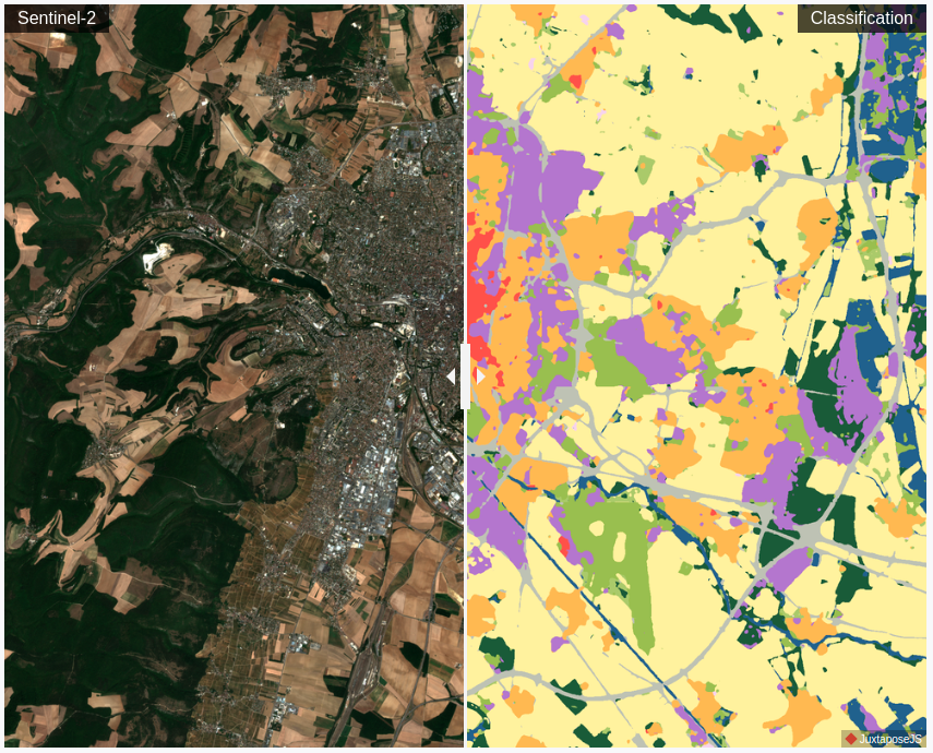
The classification results of the model for 10 land use/land cover classes for several cities in France can be viewed below.
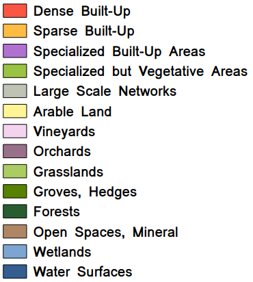
The figure below represents the legend of MultiSenGE. In this project, we resample the classes to delete the less represented ones. We merged Orchards (8) with Vineyards (7), Groves, Hedges (9) and Open Spaces, Mineral (12) with Forests (10), Wetlands (13) with Water Surfaces (14).
This work is the result of several current and previous research projects which are listed below:
- Romain Wenger, Anne Puissant, Jonathan Weber, Lhassane Idoumghar, Germain Forestier, U-Net feature fusion for multi-class semantic segmentation of urban fabrics from Sentinel-2 imagery: an application on Grand Est Region, France. International Journal of Remote Sensing, 2022, 43:6, pp.1983-2011. ⟨10.1080/01431161.2022.2054295⟩ Journal article
- Wenger, R., Puissant, A., Weber, J., Idoumghar, L., Forestier, G., MultiSenGE: a multimodal and multitemporal benchmark dataset for land use/land cover remote sensing applications. ISPRS Ann. Photogramm. Remote Sens. Spatial Inf. Sci., 2022, V-3-2022, pp.635-640. ⟨View paper⟩ Conference paper
- Romain Wenger, Anne Puissant, Jonathan Weber, Lhassane Idoumghar, Germain Forestier, A new remote sensing benchmark dataset for machine learning applications: MultiSenGE (1.0) [Data set]. Zenodo, 2022. ⟨10.5281/zenodo.6375466⟩ Dataset
To produce the large scale classification, each tile has been classified for Sentinel-1 and Sentinel-2 imagery and reprojected to Lambert-93 using the gdal command below:
$ gdalwarp -ot Byte -of GTiff -co COMPRESS=LZW -t_srs EPSG:2154 [input_file] [output_file]Then, each tile reprojected had been merged. No Data values are mapped with 0:
$ gdal_merge.py -ot Byte -of GTiff -n 0 -a_nodata 0 -co COMPRESS=LZW -o [output_file] [input_files ...]Finally, merging results has been cut using the shape of the Grand-Est region:
$ gdalwarp -tr 10.0 10.0 -ot Byte -of GTiff -co COMPRESS=LZW -cutline [Grand_Est.shp] -crop_to_cutline [input_file] [Grand_Est_2018.tif]Grand-Est classification for 2018:
Grand-Est classification for 2022:
You can download the style file for both classifications.
We produced change detection maps for some cities in the Grand-Est region:
Chalon-Champagne
Strasbourg – Shopping Promenade
Strasbourg – Construction site
Reims – New Specialized Built-Up Areas
Here are the dates of the Sentinel-2 images selected per tile to perform the 2018 classification:
| T31TFN | 27 July 2018 | 16 August 2018 | 25 September 2018 | 20 October 2018 |
| T31UEP | 15 July 2018 | 18 August 2018 | 28 September 2018 | 13 October 2018 |
| T31UEQ | 25 July 2018 | 04 August 2018 | 8 September 2018 | 17 November 2018 |
| T31UER | 25 July 2018 | 04 August 2018 | 18 September 2018 | 17 November 2018 |
| T31UFP | 27 July 2018 | 16 August 2018 | 20 September 2018 | 15 October 2018 |
| T31UFQ | 27 July 2018 | 16 August 2018 | 25 September 2018 | 20 October 2018 |
| T31UFP | 27 July 2018 | 16 August 2018 | 20 September 2018 | 15 October 2018 |
| T31UFR | 2 July 2018 | 16 August 2018 | 10 October 2018 | 4 November 2018 |
| T31UGP | 2 July 2018 | 6 August 2018 | 20 September 2018 | 15 October 2018 |
| T31UGQ | 27 July 2018 | 16 August 2018 | 25 September 2018 | 20 October 2018 |
| T32TLT | 29 July 2018 | 28 August 2018 | 27 September 2018 | 22 October 2018 |
| T32ULU | 9 July 2018 | 3 August 2018 | 27 September 2018 | 12 October 2018 |
| T32ULV | 24 July 2018 | 18 August 2018 | 27 September 2018 | 22 October 2018 |
| T32UMU | 9 July 2018 | 3 August 2018 | 17 September 2018 | 17 October 2018 |
| T32UMV | 9 July 2018 | 3 August 2018 | 27 September 2018 | 11 November 2018 |
Classification results over 5 cities in France
Dijon is a French city, prefecture of the Côte-d'Or department and capital of the Bourgogne-Franche-Comté region.
Orléans is a city in the Center-Northwest of France on the banks of the Loire, prefecture of the Loiret department and capital of the Centre-Val de Loire region.
Lille is a city in the north of France, prefecture of the Nord department and capital of the Hauts-de-France region.
Rennes is a city in the North-West of France, capital of the Ille-et-Vilaine department and of the Brittany region.
Classification results over other world cities
Brême is a city in the North of Germany not far from the North Sea.
Seville is a city in the South of Spain.
Get the MultiSenGE dataset
Sentinel-1 & Sentinel-2 time series, land cover labels and pretrained model weights, freely available for research use.